Rutgers Joins the BTAA Geoportal
Universitywide
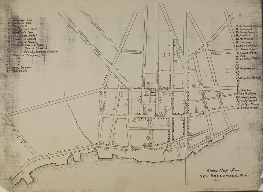
Early map of New Brunswick, NJ
Rutgers University–New Brunswick is the newest member of the Big Ten Academic Alliance Geospatial Information Network (BTAA-GIN). As of Fall 2022, the Rutgers–New Brunswick Libraries have contributed 4,576 new records to the BTAA Geoportal (collection record | browse link). These records come from the previously digitized "Maps of New Jersey" collection, which spans over 300 years of the state's development from geographic, geologic, political, environmental, and historical perspectives. This digital collection is drawn from multiple repositories, including Rutgers Special Collections and University Archives, the New Jersey Environmental Digital Library, and several public library partners of the New Jersey Digital Highway.
Included in the Rutgers collection are some rare and unique items from Special Collections and University Archives, such as this "Early Map of New Brunswick," which Francesca Giannetti, digital humanities librarian at Rutgers University Libraries, often uses in her mapping workshops to invite discussion about the similarities and differences with Google Maps, with which familiarity can generally be assumed. The comparison surfaces the ahistoricity of Google's interface as well as its slightly different prioritization of markers for commercial interests over public institutions and churches. Less frequently noticed is the fact that north is actually to the right in the historical map. Probing the reasons why New Brunswick might have been positioned above the Raritan River can be used as an invitation to examine the motivations and ideological underpinnings behind other cartographic conventions, such as meridians and projections.
The Libraries' participation in the BTAA Geoportal will help increase exposure to the Rutgers cartographic and GIS collections and open the geospatial door to the state of New Jersey. To better serve their users, the Libraries are gradually updating older JPEG presentation files with IIIF-compatible pyramidal TIFFs.
Special thanks are owed to Karen Majewicz, Melinda Kernik, and members of the BTAA-GIN Metadata Committee for their assistance with data cleanup, the addition of bounding boxes, and IIIF troubleshooting. The metadata and digital library work of many Libraries employees is now visible in the BTAA Geoportal, including that of Rhonda Marker, Isaiah Beard, Chad Mills, Al King, and Sue Oldenburg.